
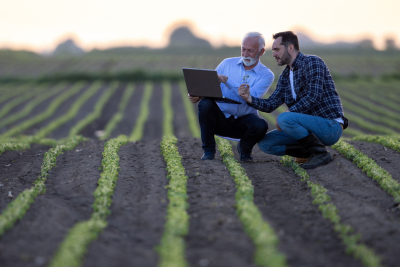
AI-powered Agricultural Sustainability Solution
Features:
- Reduce Carbon Footprint
- Monitor Water Usage
- Improve Soil Health
- Enforce Climate-smart Agriculture Practices
- Track and Report Sustainability Goals
Brands that trust us


Easy-to-deploy sustainability solutions for a greener tomorrow
Rooted in agri-sciences and powered by remote sensing and artificial intelligence
-
Monitor Deforestation/Afforestation with Land Use & Land Change (LULC) Models
Use our LULC models to distinguish between forest and agricultural land. Track plot encroachment into nearby forest land (or vice versa), and amount of encroachment over a specific configurable duration. Flag deforestation for each plot by LULC category and acreage of deforestation.
-
Assess Cover Crops with Cover Crop Monitoring Models
Detect and monitor the growth of cover crops during off seasons. Get duration and termination dates of cover crops with our cover crop monitoring models. Use insights from the model data to design farm guidelines such as boundary trees, crop rotation, mulching etc. to increase crop residue and long-term climate resilience.
-
Capture Forest Aboveground Biomass (FAGB) details with FAGB Models
Get insights into the presence of FAGB from our FAGB models powered with radar satellite imagery at specific time intervals. The model also calculates predicted biomass and difference in Mg/ha.
-
Enforce Irrigation Practices with Irrigation Advisory Models
Quantify water usage by crop at a plot-level with crop-specific irrigation advisory models which also account for soil moisture and precipitation. Broadcast advisories to farmers on schedules and amount of irrigation to prevent wastage and rot.
-
Track Irrigation Practices with Water Stress Models
Monitor plot irrigation practices and water stress with Land Surface Water Index (LSWI) index on plot maps. The index is computed through hypertuned parameters based on multiple geos and crop knowledge graphs related to crop stage.
-
Regulate Pesticide Use with Disease Early Warning System (DEWS) Model
Stop and regulate preventive pesticide spraying schedules with predictive disease and pest intelligence from the DEWS model. Using historical data and weather forecasts, the model computes the probability of disease occurrence by date. Being hyper-tuned to the disease resistance of crop varieties within a crop family, it reduces pesticide consumption, thereby enhancing yield quality and conserving soil health.
-
Schedule fertilizer spray with Crop Health Models
Validate and schedule timely spraying of fertilizers based on plant nitrogen uptake and Normalized Difference Red Edge (NDRE) index. With optimal fertilizer usage you can conserve soil pH levels while maintaining plant health
-
Analyze Tillage impact with hypertuned Tillage Assessment Models
Monitor tillage occurrence and operations by date to track farmer activities. Our tillage assessment models are hypertuned to your tillage policy to quantify its impact on soil health and the plot’s carbon quantity
-
Configure Weather Advisory for Farmers
Get weather trends and predictions for any plot or geography on temperature, precipitation, humidity, and wind speed. Use updates and insights on weather deviations to plan your farming operations and configure alerts for farmers with agronomy advisory to adapt to changing weather conditions.
-
Propel Seed Research with Climate Data
Use climate data and insights on climate change over time as inputs in your seed research and breeding to develop climate-resilient and disease-resistant crop varieties.
-
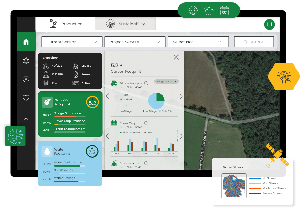
Customize dashboards per your business requirements
Adapt our sustainability dashboards to your goals and practices. Get a holistic overview of data, intelligence, programs & partners in one place to manage & monitor target based progress in real time, such as percentage reduction in carbon footprint or water usage, etc.
-
Get industry and crop variety specific insights
Our agri-models are hypertuned to multiple geos, crop varieties, and crop stages to ensure modular tracking of key ground level data, water usage, carbon levels, soil health & nutrient, supported with detailed drill-downs throughout the reporting hierarchy.
-
Integrate data from 3rd party sources for enhanced reporting and insights
Use APIs to send data from 3rd part party apps such as drones, IoT devices and other agri-data sources into Cropin Cloud. Process incoming data pipelines with pre-built advanced data frameworks and utilize the power of unified data to surface significant insights and value for your business.
Digital revolution for a sustainable business
Integrated agriculture cloud powered by agri-science and artificial intelligence
Evolve into a sustainable green business
- Drive total digital transformation to increase transparency and predictability of your farming operations.
- Use data and AI to generate actionable insights and enforce sustainable practices across the agri-supply chain.
- Seamlessly transition to a green business with a comprehensive and unified view of your global operations.
Get recognized with valuable certifications
- Get sustainability reports with AI/ML-powered data analytics on a plethora of farm data collected throughout your farming and supply chain operations.
- Integrate data from multiple sources (including 3rd parties) in fully customizable dashboards.
- Arm yourself with all the reporting requirements to receive sustainability-related certifications from certifying bodies.
Bolster brand loyalty & competitive edge
- Bolster brand loyalty & competitive edge
- Unlock the full potential of digitization to cater to the paradigm shift in consumer interest towards eco-friendly businesses.
- Drive customer loyalty with reportable ethical and sustainable business practices and boost your brand's reputation to drive profitability.
Trusted by the Champions of Change shaping a Sustainable Future
Dive into our case studies to witness the impact of our solutions
Gebana
- 100% digitization of farm data across 22000+ hectares
- Certification program for producers
- Demand forecasting
- Weather alerts, real-time insights, and advisories for 8000+ farmers

Loacker
- Managing 85+ farmers across 95+ plots
- Acres of audited Area: 225+
- Tonnes of harvest: 2000+

Food & beverage producer
- 90% accuracy in Weather Prediction
- 87% accuracy in Disease Warning
- 84% accuracy in Canopy Greenness
- 80% accuracy in Nitrogen Uptake & Water Stress Identification